
Exploring the Western High Atlas Mountains in Morocco
- Feb 20
- 6 min read

Epic Landscapes, Legendary Mountain Passes and Real Outdoor Adventure
Less than two hours from Marrakech, the Western High Atlas reveals a wilder, more authentic and more intense side of Morocco. Lush valleys, traditional Berber villages built from rammed earth, high-altitude plateaus, dramatic mountain roads and legendary passes : every area offers its own distinct atmosphere and breathtaking scenery.
It’s a destination where raw nature, living traditions and epic landscapes come together to create one of the most rewarding travel experiences in the Moroccan Atlas Mountains.

Ourika Valley
Accessible Nature and Authentic Berber Culture
South of Marrakech, the Ourika Valley is the most visited area of the High Atlas Mountains. Popular with locals from Marrakech looking to escape the heat, it also draws travelers eager to experience traditional Berber rural life.
Nearby, Setti Fatma enjoys temperatures that are typically 10 to 15°C cooler than the city, making it a refreshing retreat, especially in summer. The valley can easily be explored as a day trip from Marrakech, but staying overnight in one of the charming guesthouses or eco-lodges allows for a deeper and more authentic Atlas Mountains experience.
HOW TO GET THERE
BUS
Bus No. 25 from Sidi Mimoun (around 2 hours)
GRAND TAXI or CAR RENTAL
(About 1.5 hours from Marrakech). Keep in mind there are no gas stations beyond Tnine-l’Ourika.
What to See and Do in the Ourika Valley

The 7 Waterfalls
The most popular hike takes you to the first three waterfalls in about 1.5 hours. Reaching all seven waterfalls requires roughly a 4-hour round trip and sturdy footwear.
Hiring a guide is recommended, though there’s no need to book in advance — guides are readily available on site.

Dining with Your Feet in the Water
Along the river, small cafés and terraces set up tables, sometimes right in the water, connected by charming little footbridges.
These cozy spots serve simple, affordable Moroccan dishes, from steaming tagines to freshly grilled meats.

Hikes and Walking Trails
The valley also serves as a starting point for multi-day treks, such as the route to the Timenkar Plateau, returning via the Tizi’n’Chiker Pass (2,800 m), or the trek to Imlil (2–3 days) through the Tachduret and Tamatert passes, with the option to summit Mount Toubkal.
Looking to go further:
Allmoov tours, available by 4x4 or electric mountain bike, offer full-day or multi-day itineraries with full board, allowing you to explore the valley’s landscapes and villages at a relaxed, immersive pace.

Oukaïmeden
Between Peaks and High-Altitude Pastures
Oukaïmeden is Africa’s highest ski resort and one of Morocco’s best-equipped, featuring six chairlifts and surface lifts. The ski area covers 300 hectares, with elevations ranging from 2,600 m at the base to 3,270 m at the summit, though snow conditions vary from year to year.
In summer, the mountain transforms into expansive pastures for shepherds and their flocks. The road up to Oukaïmeden is spectacular: starting among agaves and prickly pear cacti, it gradually gives way to shrubs, cedar forests, and ochre stone fields, with breathtaking views over rammed-earth villages clinging to the mountainside.
HOW TO GET THERE
BUS
There is no direct bus from Marrakech to Oukaïmeden.
GRAND TAXI or CAR RENTAL
If you don’t have a car, you’ll need to take a grand taxi from Marrakech.
What to See and Do in Oukaïmeden

Skiing and Snow Sports
Just 75 km from Marrakech, Oukaïmeden lets you experience skiing on its slopes, with equipment rental shops available on site (season permitting!).

Hikes
From May to November, numerous trails offer scenic high-altitude hikes and the chance to discover ancient rock carvings. A good level of fitness is required, and hiring a guide is recommended.

Other options
Paragliding, electric biking, or mountain biking are available by reservation from Marrakech, with transportation usually included.
Imlil
At the Foot of Toubkal: The Heart of the High Atlas
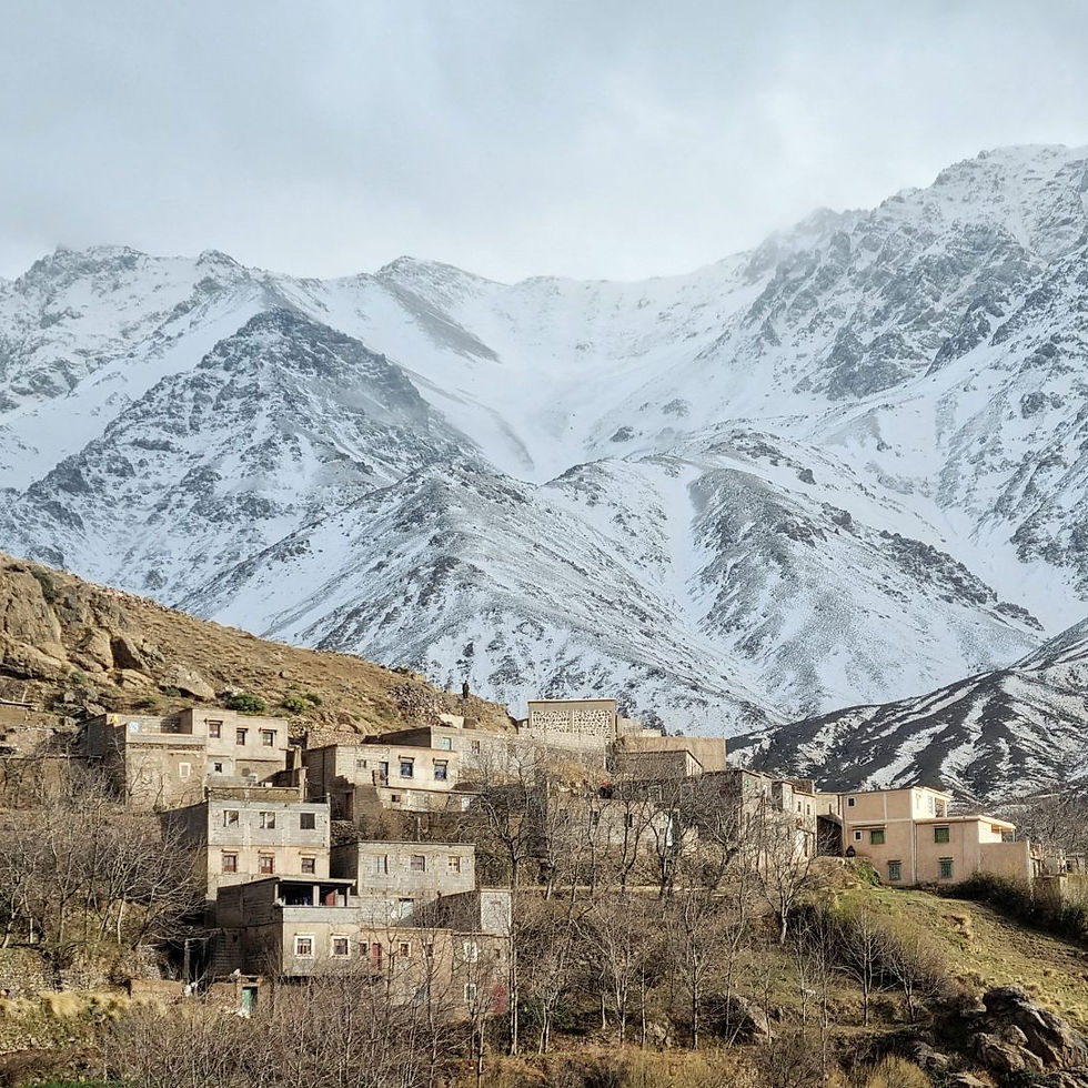
Nestled in the heart of the High Atlas Mountains, Imlil is a picturesque village and one of the best starting points for exploring the region. It also serves as the base for summiting Toubkal, Morocco’s highest peak, as well as for numerous hikes within Toubkal National Park.
HOW TO GET THERE
GRAND TAXI
From Marrakech, you can easily catch a grand taxi to Imlil.
CAR
Imlil is also accessible by car from Marrakech, taking around 1.5 hours.
What to See and Do in Imlil ?

Moulay Ibrahim
A famous pilgrimage site for women hoping to conceive, where small ribbons are tied to tree branches as a symbol of their prayers. It can be reached on a hike from Imlil.

Jebel Toubkal (4 167 m)
The highest peak in North Africa. A guide is mandatory, especially when snow is present, even if rare in summer. It’s easier to climb than Tazagart but often crowded, making the choice of a skilled guide essential.
Upper Tachdift Valley
Located 17 km from Imlil, the road climbs up to Tachdirt (2,400 m), Morocco’s highest village, nestled in an impressive mountain amphitheater that provides the perfect setting for stunning hikes.

Tazagart Plateau
A pristine area with breathtaking landscapes, perfect for those seeking challenging hikes and a true sense of vastness.
The Amizmiz road
Arid Hills and Panoramic Plateau
The Amizmiz Road is one of the most beautiful escapes from Marrakech. Easily done in a day, it winds through arid hills and open plateaus, with the majestic High Atlas peaks as a backdrop on clear days.
Full of striking contrasts, this route offers a gradual immersion into raw nature, quiet villages, and breathtaking panoramic views.
HOW TO GET THERE
CAR
By car, completely self-guided.
PRIVATE TRANSFERT
Organized excursions or local transport providers from Marrakech.
What to See and Do on the Amizmiz Road ?

Lalla Takerkoust
Just 33 km from Marrakech, Lalla Takerkoust Lake and its dam, built during the French Protectorate, provide a peaceful natural escape. While swimming is prohibited, the area charms visitors with its tranquil scenery and wide-open spaces.

Kik Plateau
The Kik Plateau sits in the heart of the High Atlas foothills, overlooking Lalla Takerkoust Lake and surrounded by gorges and verdant hills. Exploring it can easily be part of a full-day electric bike tour with Allmoov circuits.

Outdoor Sports
Between Lalla Takerkoust and Asni, a vast undulating plateau stretches out between the lake, the Agafay Desert, and the first foothills of the Atlas. This is where our Allmoov Marrakech base is located, a strategic starting point for exploring the entire region.
Tizi n’Test road
One of Morocco’s Most Scenic Mountain Roads
Beyond Asni, the R203 winds deep into the High Atlas, forming one of Morocco’s most stunning and dramatic mountain roads. It climbs up to the Tizi n’Test Pass at 2,260 m before descending toward Taroudant.
The scenery alternates between dry, rocky zones, cultivated mountain oases, and kasbahs perched on the hillsides. The road is winding and sometimes narrow, making it a true paradise for cycling enthusiasts.
HOW TO GET THERE
CAR
By car, completely self-guided.
PRIVATE TRANSFERT
Organized excursions or local transport providers from Marrakech.
What to See and Do on the Tizi n’Test Road ?

Ouirgane
Just 60 km from Marrakech, nestled in a quiet foothill area, this natural spot offers a refreshing escape. Between the dam lake and the dramatic gorges of the Oued Nfiss, hikers of all levels can enjoy accessible trails, making it perfect for a day trip or a green weekend getaway.

Ijoukak
The road winds through the gorges of the Oued Nfiss and then the Oued Agoundis, dotted with small rammed-earth buildings. The contrast between the deep green valleys and the stark, desert-like mountains, with hues ranging from pink to purple, creates a truly unique and unforgettable atmosphere.
Tizi n'Tichka road
The Great Passage to the South
The Tizi n’Tichka Road, stretching about 200 km, crosses the High Atlas and is considered one of Morocco’s most beautiful drives. A key route between Marrakech and Ouarzazate, it winds through pine forests, oleander blooms, and terraced fields, with patches of exposed earth and rugged hills adding to the dramatic scenery.
HOW TO GET THERE
CAR
By car, completely self-guided.
PRIVATE TRANSFERT
Organized excursions or local transport providers from Marrakech.
What to See and Do on the Tizi n’Tichka Road ?

Col Tizi n'Tichka
Offering stunning views over canyons and valleys, dotted with small mineral stalls, the road requires careful driving due to its many hairpin turns up to the Tizi n’Tichka Pass, at nearly 2,260 m — Morocco’s highest mountain pass.

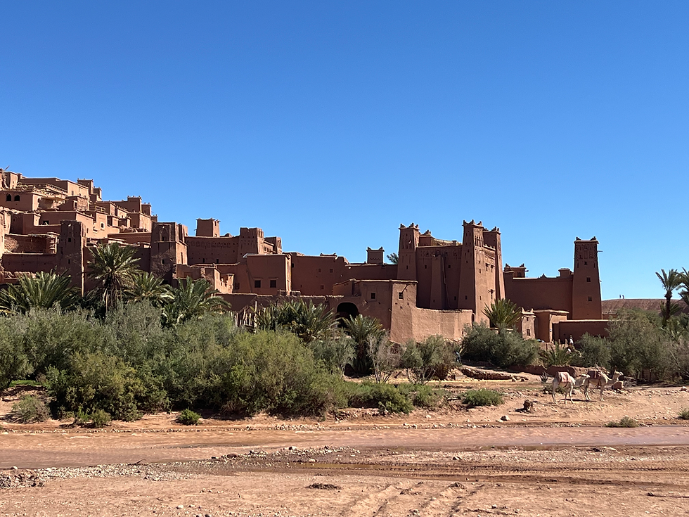
Telouet
Along the route, the village of Telouet, perched at 1,870 m, recalls its historical role as a caravan crossroads where Jews, Muslims, and Christians once coexisted. The Kasbah of the last Atlas lord impresses with its earthen architecture, while the restored red rammed-earth granary showcases 16th-century food storage traditions. Visits are ticketed, but each offers a fascinating glimpse into the area’s rich history.
Let us guide you through the High Atlas:


Comments